Land-Water-Sky Continuum Research Program
Uniting knowledge systems to read, restore and protect the Land–Water–Sky continuum.
The Two‑Eyed Seeing Space is an online community research HUB for Earth and Environmental Sciences, that functions as a working lab and design studio for on‑ground change
Land-Water-Sky Continuum Research Program
Uniting knowledge systems to read, restore and protect the Land–Water–Sky continuum.
The Two‑Eyed Seeing Space is an online community research HUB for Earth and Environmental Sciences, that functions as a working lab and design studio for on‑ground change
Our Vision
Our vision is to walk with Country as a living teacher, restoring right relationships across the Land–Water–Sky Continuum.
We seek to uphold true 50:50 parity between Traditional Cultural Knowledge and Western Science, so that every decision about land, water and climate is guided by Elder knowledge, cultural safety and independently verifiable scientific evidence.
By sharing methods, data and stories, we aim to help communities everywhere rehydrate their landscapes, strengthen flying rivers and stabilise climates, allowing us to pass on healthy, productive and sustainable landscapes, communities and economies to future generations.
Our Vision
Our vision is to walk with Country as a living teacher, restoring right relationships across the Land–Water–Sky Continuum.
We seek to uphold true 50:50 parity between Traditional Cultural Knowledge and Western Science, so that every decision about land, water and climate is guided by Elder knowledge, cultural safety and independently verifiable scientific evidence.
By sharing methods, data and stories, we aim to help communities everywhere rehydrate their landscapes, strengthen flying rivers and stabilise climates, allowing us to pass on healthy, productive and sustainable landscapes, communities and economies to future generations.
Land-Water-Sky Continuum Research Program:
The Land–Water–Sky Continuum Research Program is a Two‑Eyed Seeing initiative that treats climate not as “weather in the air” but as a single, living system linking landforms, soils, waters, vegetation, atmosphere and people.
Working under UHESP v2.1 and UHIP v2.2, the program uses seven interconnected landscape processors (heating/pressure, hydrological connectivity, flow regimes, succession, structure and layering, biodiversity and morphology) to show how local management of water, vegetation and fire scales up to regional and continental climate regulation via the biotic pump and flying rivers.
Traditional Cultural Knowledge and Western science are held in strict 50:50 parity: Songlines, seasonal calendars and Lore provide the primary explanatory frame, while satellite data, The Bureau of Meteorology (BoM) records and flux towers quantify the same patterns, achieving 80–96% alignment across sites from Bungonia farm to the Tumbarumba continental forest network.
Two-Eyed Seeing:
Two-Eyed Seeing, or Etuaptmumk in the Mi’kmaq language, was introduced by Mi’kmaq Elders Albert and Murdena Marshall alongside Professor Cheryl Bartlett. It encourages viewing the world through one eye with the strengths of Indigenous knowledge and through the other eye with the strengths of Western knowledge, using both eyes together‑
Originating in Canada and adapted here for Australia under the UHESP v2.1 and UHIP v2.2 protocols, it asks people to “see with one eye” the relational, place‑based science held in Songlines, Dreaming stories, seasonal calendars and Law, and “with the other eye” the measurements and models from satellites, gauges and experiments.
In the Land–Water–Sky Continuum Research program, Two‑Eyed Seeing is not just a metaphor but a protocol: Elder‑governed TCK sets the questions and boundaries, Western science quantifies patterns like the seven landscape processors and flying rivers, and the two streams are held in 50:50 parity to produce genuinely holistic intelligence for landscape climate restoration and governance decisions.
Co‑operative Succession Framework:
Landscape and Climate Restoration
Combining Traditional Cultural Knowledge with Australian Landscape Science, through the Two‑Eyed Seeing framework, enables us to develop restoration programs that repair damaged landscapes quickly, rebuild the small water cycle, and strengthen Land–Water–Sky connections within just a few years. Our Co‑operative Succession framework is being refined and further developed in partnership with Yurruungga Aboriginal Corporation.
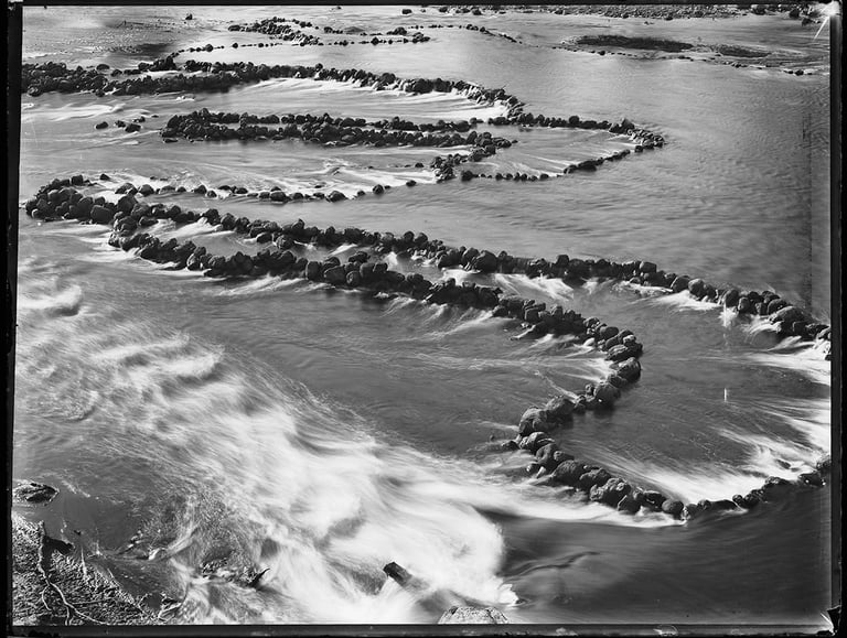
We will be looking at combining fire‑pulse with our existing water‑pulse landscape rehydration system, grounded in Natural Sequence Farming and Traditional Fish‑Trap and floodplain engineering. Landscape rehydration works will be paired with traditional cool mosaic burning, timed with water pulses, cultural calendars, and Traditional plant and animal cues.
Restoration programs will prioritise locations and design that will enhance songline connectivity and biocultural corridors, optimising Land–Water–Sky connections, and restoring ecological and climate function. All ground works will be supported by satellite and on‑ground monitoring under Elder‑led governance and benefit‑sharing rules.


Kariong Storm Water Catchment and Filtration System - Demonstration Site For Water-Pulse Restoration:
Water‑pulse restoration is a practical way of rehydrating and repairing damaged landscapes by slowing, spreading, and soaking rainfall so it infiltrates into soil rather than rushing away in erosive floods. It draws on Natural Sequence Farming and Indigenous Landmanagement practices to rebuild the “small water cycle”: reconnecting hilltops, slopes, floodplains, wetlands, and streams so that each rain event becomes a gentle pulse that recharges groundwater, feeds plants and soil life, and moderates local climates instead of driving droughts and flash floods.
Water Pulse and the Land Heartbeat:
Elder John W.
"The land has a pulse, just like you and me. When the rains come, the earth doesn’t just get wet; it drinks in a specific, rhythmic pulse. The water moves through the underground tracks, following the songlines of the ancestors. If we incision the soil with deep drains or hard roads, we break that heart rhythm. The water speeds up, it gets angry, and it cuts into the earth instead of healing it. Quantum sensors now show us this resonance—a low-frequency vibration that occurs when a landscape is properly hydrated. We always knew this as the "Singing of the Country." When the water flows slowly and settles in the chains of ponds, the whole landscape breathes together in harmony."


Completed ground works -12/02/2010
Established wetland function with water storage and filtration - Recent planting of riparian vegetation - 31/10/2014
Established nature corridor and water pulse demonstration site- 30/04/2024
Click this link below to listen to our AI generated Podcast discussing UHIP v2.2 and UHESP v2.1, the two main protocols used in our AI systems - 2 Protocols 1 Planet -
Land-Water-Sky Continuum Research Program:
The Land–Water–Sky Continuum Research Program is a Two‑Eyed Seeing initiative that treats climate not as “weather in the air” but as a single, living system linking landforms, soils, waters, vegetation, atmosphere and people.
Working under UHESP v2.1 and UHIP v2.2, the program uses seven interconnected landscape processors (heating/pressure, hydrological connectivity, flow regimes, succession, structure and layering, biodiversity and morphology) to show how local management of water, vegetation and fire scales up to regional and continental climate regulation via the biotic pump and flying rivers.
Traditional Cultural Knowledge and Western science are held in strict 50:50 parity: Songlines, seasonal calendars and Lore provide the primary explanatory frame, while satellite data, The Bureau of Meteorology (BoM) records and flux towers quantify the same patterns, achieving 80–96% alignment across sites from Bungonia farm to the Tumbarumba continental forest network.
Two-Eyed Seeing:
Two-Eyed Seeing, or Etuaptmumk in the Mi’kmaq language, was introduced by Mi’kmaq Elders Albert and Murdena Marshall alongside Professor Cheryl Bartlett. It encourages viewing the world through one eye with the strengths of Indigenous knowledge and through the other eye with the strengths of Western knowledge, using both eyes together‑
Originating in Canada and adapted here for Australia under the UHESP v2.1 and UHIP v2.2 protocols, it asks people to “see with one eye” the relational, place‑based science held in Songlines, Dreaming stories, seasonal calendars and Law, and “with the other eye” the measurements and models from satellites, gauges and experiments.
In the Land–Water–Sky Continuum Research program, Two‑Eyed Seeing is not just a metaphor but a protocol: Elder‑governed TCK sets the questions and boundaries, Western science quantifies patterns like the seven landscape processors and flying rivers, and the two streams are held in 50:50 parity to produce genuinely holistic intelligence for landscape/climate restoration and governance decisions.
Co‑operative Succession Framework:
Landscape and Climate Restoration Combining Traditional Cultural Knowledge with Australian Landscape Science, through the Two‑Eyed Seeing framework, enables us to develop restoration programs that repair damaged landscapes quickly, rebuild the small water cycle, and strengthen Land–Water–Sky connections within just a few years. Our Co‑operative Succession framework is being refined and further developed in partnership with Yurruungga Aboriginal Corporation.
We will be looking at combining fire‑pulse with our existing water‑pulse landscape rehydration system, grounded in Natural Sequence Farming and Traditional Fish‑Trap and floodplain engineering. Landscape rehydration works will be paired with traditional cool mosaic burning, timed with water pulses, cultural calendars, and Traditional plant and animal cues.
Restoration programs will prioritise locations and design that will enhance songline connectivity and biocultural corridors, optimising Land–Water–Sky connections, and restoring ecological and climate function. All ground works will be supported by satellite and on‑ground monitoring under Elder‑led governance and benefit‑sharing rules.

Kariong Storm Water Catchment and Filtration System - Demonstration Site For Water-Pulse Restoration:
Water Pulse and the Land Heartbeat:
Elder John W.
"The land has a pulse, just like you and me. When the rains come, the earth doesn’t just get wet; it drinks in a specific, rhythmic pulse. The water moves through the underground tracks, following the songlines of the ancestors. If we incision the soil with deep drains or hard roads, we break that heart rhythm. The water speeds up, it gets angry, and it cuts into the earth instead of healing it. Quantum sensors now show us this resonance—a low-frequency vibration that occurs when a landscape is properly hydrated. We always knew this as the "Singing of the Country." When the water flows slowly and settles in the chains of ponds, the whole landscape breathes together in harmony."


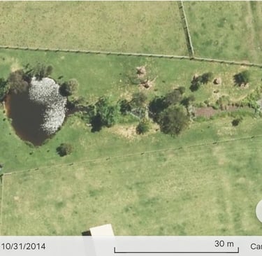
Water‑pulse restoration is a practical way of rehydrating and repairing damaged landscapes by slowing, spreading, and soaking rainfall so it infiltrates into soil rather than rushing away in erosive floods. It draws on Natural Sequence Farming and Indigenous Landmanagement practices to rebuild the “small water cycle”: reconnecting hilltops, slopes, floodplains, wetlands, and streams so that each rain event becomes a gentle pulse that recharges groundwater, feeds plants and soil life, and moderates local climates instead of driving droughts and flash floods.
Completed ground works -12/02/2010
Established wetland function with water storage and filtration - Recent planting of riparian vegetation - 31/10/2014
Established nature corridor and water pulse demonstration site- 30/04/2024
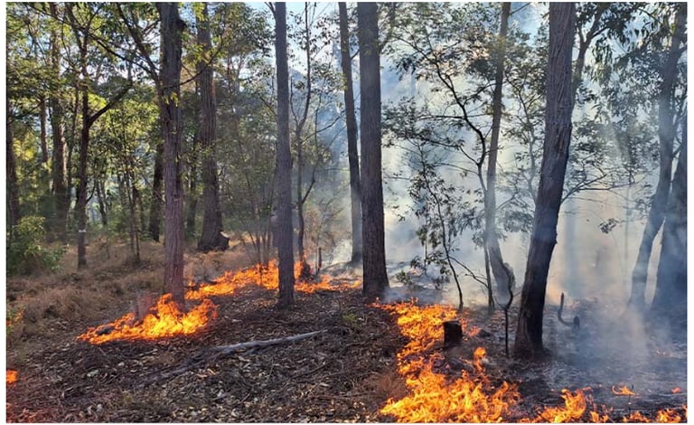
Soil Guardianship and the Underground Fire:
Elder Sarah T.
The cool burn is a way of talking to the soil. In the old times, we watched the tiny insects; if they could crawl over the ash without burning their legs, the fire was right. This gentle smoke wakes up the seeds that have been sleeping for years, sometimes decades, without hurting the small spirits in the roots. It clears the heavy fuel but leaves the skin of the earth intact. When the first rains finally arrive, they don’t wash the country away; the land is ready to drink deeply. The charcoal acts as a sponge, holding onto that precious moisture and feeding the new growth that will feed the kangaroos. This is how we keep the country healthy and safe from the big, angry fires that kill everything in their path."
Traditional Cultural Knowledge:
Traditional Cultural Knowledge (TCK) is not a data source we “add into” science; it is a complete relational science in its own right, carried through stories, songlines, ceremonies, law and responsibilities to Country. It describes how Land, Water, Sky and people are meant to move together, setting the frame within which any technical monitoring or modelling must sit.
In this work, TCK is held at true 50:50 parity with Western science: Elders and knowledge holders define what can be shared, how it is interpreted, and how benefits flow back to community, while satellites and instruments add fine‑grained measurements inside that governance frame. All use of TCK follows strict consent, cultural safety and benefit‑sharing protocols, so that Country’s oldest knowledge systems remain sovereign while guiding new tools and analyses.
Cool Mosaic Burn
Baiame’s Ngunnhu - Brewarrina Fish Trap
Soil Guardianship and the Underground Fire:
Elder Sarah T. The cool burn is a way of talking to the soil. In the old times, we watched the tiny insects; if they could crawl over the ash without burning their legs, the fire was right. This gentle smoke wakes up the seeds that have been sleeping for years, sometimes decades, without hurting the small spirits in the roots. It clears the heavy fuel but leaves the skin of the earth intact. When the first rains finally arrive, they don’t wash the country away; the land is ready to drink deeply. The charcoal acts as a sponge, holding onto that precious moisture and feeding the new growth that will feed the kangaroos. This is how we keep the country healthy and safe from the big, angry fires that kill everything in their path."
Traditional Cultural Knowledge:
Traditional Cultural Knowledge (TCK) is not a data source we “add into” science; it is a complete relational science in its own right, carried through stories, songlines, ceremonies, law and responsibilities to Country. It describes how Land, Water, Sky and people are meant to move together, setting the frame within which any technical monitoring or modelling must sit.
In this work, TCK is held at true 50:50 parity with Western science: Elders and knowledge holders define what can be shared, how it is interpreted, and how benefits flow back to community, while satellites and instruments add fine‑grained measurements inside that governance frame. All use of TCK follows strict consent, cultural safety and benefit‑sharing protocols, so that Country’s oldest knowledge systems remain sovereign while guiding new tools and analyses.
Cool Mosaic Burn
Baiame’s Ngunnhu - Brewarrina Fish Traps
Land-Water-Sky Continuum Education
The short video below is one of 13 videos on our Land-Water-Sky Continuum Education page. The Biotic Pump: How Forests Create Rain offers a clear, visual explanation of the biotic pump – how healthy forests help “call” rain from the ocean deep into continents. It shows how dense vegetation lifts water vapour, creates low‑pressure zones, and pulls in moist air, turning forests into living moisture pumps that stabilise rainfall and prevent drought and desertification.
The Biotic Pump: How Forests Create Rain

The Flying Rivers of the High Sky:
Elder Mary G.
"In our tradition, the moisture we see moving in the sky is the breath of the ancestors moving through the great sky rivers. These are not just clouds; they are massive currents of life-giving vapor that travel from the coast deep into the desert. We must protect the forests on the coast because the trees are the pumps that push this breath further inland. If the coastal forests are cleared, the breath becomes weak, and the inland country gasps for air. We watch the Wedge-Tailed Eagle; he rides these invisible rivers, showing us where the moisture is thickest. Protecting the Land is the only way to ensure the Sky Rivers continue to flow and feed the hidden springs of the interior."
Click the link below to watch more educational videos about the Land-Water-Sky Continuum
Land-Water-Sky Continuum Education
The short video below is one of 13 videos on our Land-Water-Sky Continuum Education page. The Biotic Pump: How Forests Create Rain offers a clear, visual explanation of the biotic pump – how healthy forests help “call” rain from the ocean deep into continents. It shows how dense vegetation lifts water vapour, creates low‑pressure zones, and pulls in moist air, turning forests into living moisture pumps that stabilise rainfall and prevent drought and desertification.
The Biotic Pump: How Forests Create Rain
The Flying Rivers of the High Sky:
Elder Mary G.
"In our tradition, the moisture we see moving in the sky is the breath of the ancestors moving through the great sky rivers. These are not just clouds; they are massive currents of life-giving vapor that travel from the coast deep into the desert. We must protect the forests on the coast because the trees are the pumps that push this breath further inland. If the coastal forests are cleared, the breath becomes weak, and the inland country gasps for air. We watch the Wedge-Tailed Eagle; he rides these invisible rivers, showing us where the moisture is thickest. Protecting the Land is the only way to ensure the Sky Rivers continue to flow and feed the hidden springs of the interior."
Quantum Biology:
Quantum Biology proposes that molecular‑scale quantum effects in photosynthesis and enzymes scale up, via networks of roots, fungi, plants, and the atmosphere, into ecosystem‑level “computation” and climate regulation. Under Two‑Eyed Seeing, Western quantum biology describes mechanisms (coherence, tunnelling, superradiance), while TCK describes how Country “thinks” remembers, and regulates the Land–Water–Sky continuum.
Two-Eyed Synthesis: Data as Song
Elder Victor W.
"Two-Eyed Seeing is like having two paths to the same mountain peak. One eye sees the numbers, the sensors, and the charts. The other eye sees the patterns, the spirits, and the stories. When we combine them, we don't just see the "what," we see the "why." In this Space, we treat the data from the quantum array as a modern form of song—a rhythmic representation of the country's current state. By weaving this song with the ancient stories of the elders, we create a roadmap for healing that is both technically precise and culturally grounded. This is the final frontier of climate understanding: the marriage of the ancient and the emergent."

Plants Are Quantum Computers?!
In the video below, “Plants Are Quantum Computers?!”, you’ll explore how photosynthetic systems use quantum coherence and superposition to move light energy through their pigment networks with extraordinary efficiency, effectively testing many paths at once to find the best route.
Quantum Biology:
Quantum Biology proposes that molecular‑scale quantum effects in photosynthesis and enzymes scale up, via networks of roots, fungi, plants, and the atmosphere, into ecosystem‑level “computation” and climate regulation. Under Two‑Eyed Seeing, Western quantum biology describes mechanisms (coherence, tunnelling, superradiance), while TCK describes how Country “thinks” remembers, and regulates the Land–Water–Sky continuum.
Two-Eyed Synthesis: Data as Song
Elder Victor W.
"Two-Eyed Seeing is like having two paths to the same mountain peak. One eye sees the numbers, the sensors, and the charts. The other eye sees the patterns, the spirits, and the stories. When we combine them, we don't just see the "what," we see the "why." In this Space, we treat the data from the quantum array as a modern form of song—a rhythmic representation of the country's current state. By weaving this song with the ancient stories of the elders, we create a roadmap for healing that is both technically precise and culturally grounded. This is the final frontier of climate understanding: the marriage of the ancient and the emergent."
Plants Are Quantum Computers?!
In the video below, “Plants Are Quantum Computers?!”, you’ll explore how photosynthetic systems use quantum coherence and superposition to move light energy through their pigment networks with extraordinary efficiency, effectively testing many paths at once to find the best route.
Satellite and on‑ground monitoring:
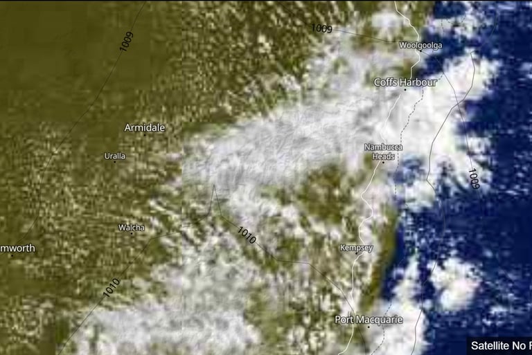
We use satellite and on‑ground monitoring together so that every claim about landscape and climate function can be checked in near real time using our "Real-Time Validation workflows".
Public satellite platforms, including Earth Nullschool, Meteoblue, NASA Worldview, Google Earth Engine, BoM and ERA5, track flying rivers, pressure gradients, NDVI, soil moisture and fire timing, while field measurements, including BOM Weather stations/river gauges and OzFlux towers, and community observations such as species shifts and cultural calendar cues on Country, ground truth satellite data and track success indicators.
All monitoring is interpreted through Two‑Eyed Seeing: Elder‑led readings of signs, seasons and songlines sit alongside quantitative metrics, and results are logged under our Real‑Time Validation Workflows so partners can see exactly how each conclusion was reached.
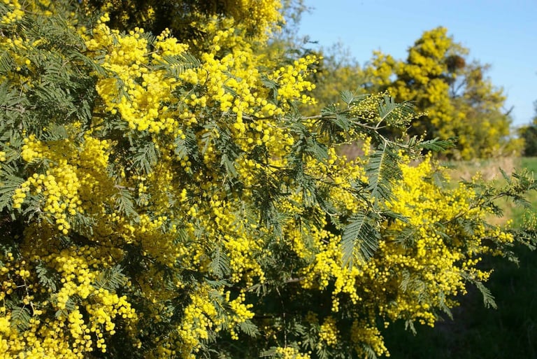
The Wattle’s Golden Clock:
Elder Thomas B.
"The flowering of the Silver Wattle is not just a pretty sight; it is a vital signal from the soil country. It tells us the temperature deep in the roots has shifted from the cold of winter to the waking energy of spring. It is a clock for the fish moving upstream; when the yellow dust falls into the water, the trout are ready. It is a sign that the frost-time is ending and the ground is soft enough for planting. We watch how the bees interact with the blossoms—if they are busy and loud, the season will be long and fruitful. If the flowers drop early, we know to prepare for a dry summer. This golden signal connects the deep soil temperature to the movements of every living thing in the valley."
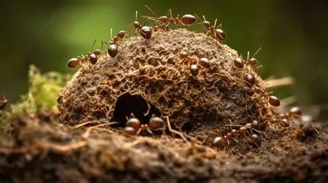
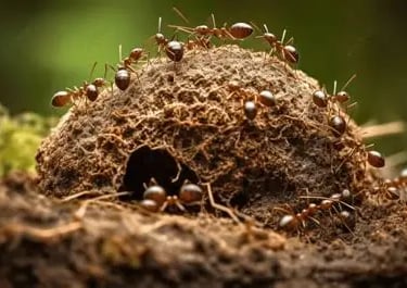
Ant Mounds and the Coming Flood
Elder Grace L.
"Always watch the ants, for they are the earth’s most sensitive listeners. Long before our instruments show a drop in pressure, the ants feel the shift in their tiny legs. When you see them building their mounds higher than usual, and sealing the entrance holes with a specific red clay, you must prepare. They are waterproofing their nurseries because the sky country is preparing to open its gates. They move their eggs to the very highest chambers to keep them dry. We have seen them do this days before a storm breaks. Their connection to the soil’s moisture and the air’s weight is a form of science that has kept our people safe through floods for thousands of generations."


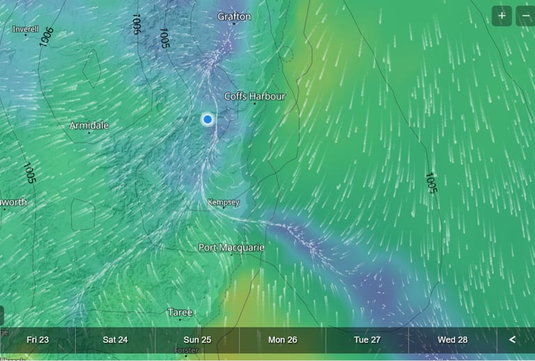
Satalite visualisation of wind - Meteoblue
Satalite image - Meteoblue
Click the link below to hear an AI-generated podcast, doing a deep dive discussion into the Ourimbah State Forest Comprehensive Historical Network Analysis
Satellite and on‑ground monitoring:
We use satellite and on‑ground monitoring together so that every claim about landscape and climate function can be checked in near real time using our "Real-Time Validation workflows".
Public satellite platforms, including Earth Nullschool, Meteoblue, NASA Worldview, Google Earth Engine, BoM and ERA5, track flying rivers, pressure gradients, NDVI, soil moisture and fire timing, while field measurements, including BOM Weather stations/river gauges and OzFlux towers, and community observations such as species shifts and cultural calendar cues on Country, ground truth satellite data and track success indicators.
All monitoring is interpreted through Two‑Eyed Seeing: Elder‑led readings of signs, seasons and songlines sit alongside quantitative metrics, and results are logged under our Real‑Time Validation Workflows so partners can see exactly how each conclusion was reached.
The Wattle’s Golden Clock:
Elder Thomas B.
"The flowering of the Silver Wattle is not just a pretty sight; it is a vital signal from the soil country. It tells us the temperature deep in the roots has shifted from the cold of winter to the waking energy of spring. It is a clock for the fish moving upstream; when the yellow dust falls into the water, the trout are ready. It is a sign that the frost-time is ending and the ground is soft enough for planting. We watch how the bees interact with the blossoms—if they are busy and loud, the season will be long and fruitful. If the flowers drop early, we know to prepare for a dry summer. This golden signal connects the deep soil temperature to the movements of every living thing in the valley."
Ant Mounds and the Coming Flood
Elder Grace L.
"Always watch the ants, for they are the earth’s most sensitive listeners. Long before our instruments show a drop in pressure, the ants feel the shift in their tiny legs. When you see them building their mounds higher than usual, and sealing the entrance holes with a specific red clay, you must prepare. They are waterproofing their nurseries because the sky country is preparing to open its gates. They move their eggs to the very highest chambers to keep them dry. We have seen them do this days before a storm breaks. Their connection to the soil’s moisture and the air’s weight is a form of science that has kept our people safe through floods for thousands of generations."
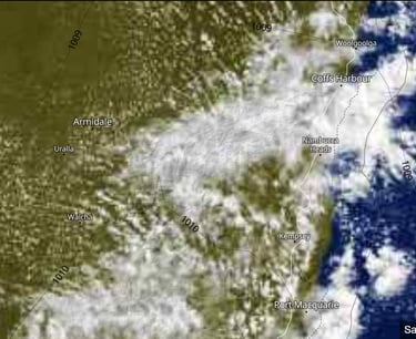
Satalite visualisation of wind
Satalite image

Contact
Reach out to discuss your project needs and how we can support you
EMAIL Ian Sutton at
TwoEyedSeeing@proton.me
© 2025. All rights reserved.


